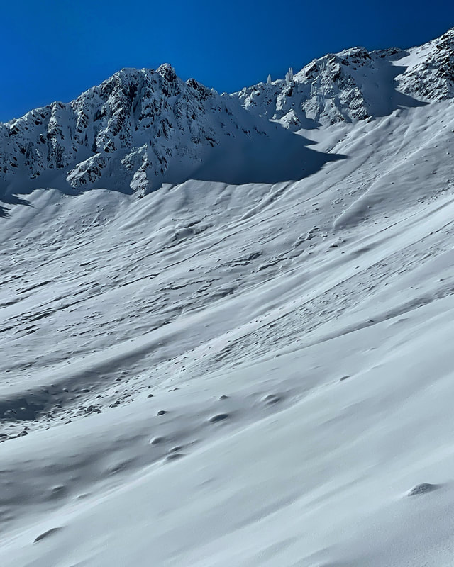
Cardiff10/31/2021 Been watching all the pics Mark has posted and figured I needed to go see it for myself. Snow on the south side made it possible to walk all the way. Some dry snow but mostly dense or crusted on all aspects. Found some decent skiing on high east facing. Light winds all day and cloud cover but not enough to keep the snow cold. Had to walk out a bit on the south side where we had snow on the way in. Going to need a bunch more in the near future if we want the skiing to be good. PI
0 Comments
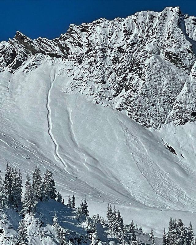
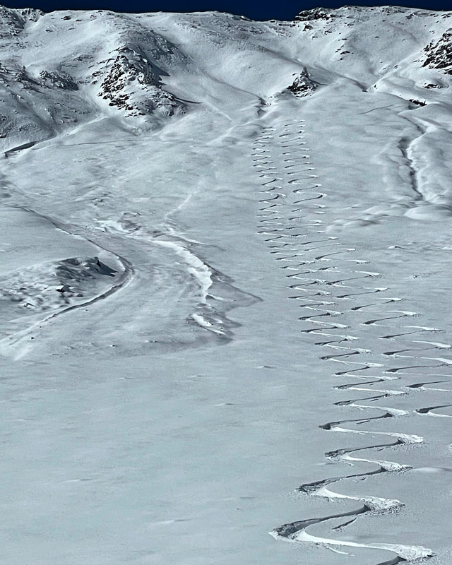
La Sals10/31/2021 Went down to the desert to go skiing, go figure. Went up to Golds Basin in the La Sal Mountains east of Moab. The La Sals are a high elevation mountain range that go up to just under 13000ft. The snow line is around 10,000ft, luckily the parking lots above is that. Right now I wouldn’t recommend traveling there due to a lot of dirt walking and modest coverage. The S facing slopes are basically dirt but the high N was holding patches of dry recrystallized powder. I dug a snow pit just below 11,000ft on a NE facing slope and found a facet crust sandwich about a foot down, probably the normal for these mountains but with the elevation, dry air and cold clear nights the whole snow pack seems destined to facet out if there is an extended dry spell. Cardiac Bowl and Ridge10/28/2021 Went Back to Cardiac today. Trying to stay at high elevations hoping the snow would remain cold but in the long run it didn’t. The new snow had settled out to about 8 inches of dense, damp, graupely snow, closest thing we get to Sierra Cement in the Wasatch. The cloud deck remained at about 10500ft most of the day with light winds and high humidity. We ended up getting suckered by a few breaks in the clouds and decided to head up Cardiac Bowl. Sat at the top for a good amount of time and ended up skiing it in a complete white out. Sorry about the hack job but guess that’s why they call it a sucker hole. We finally had enough visibility to ski the Ridge which was getting heavy green housing on our approach. By the time we had skied it even the highest north’s were roller balling and becoming damp and sticky and we knew it was time to leave. There were a few fairly large wet slides on the ridge that happened during the rain event on Monday and the debris piles are not user friendly. That said, it was a great base building storm and when it gets cold again and seizes up tight we’ll have one of the best and most stable bases I’ve seen in a long time. The only hazard I could see today was triggering a wet slide in steeper terrain. PC Ridgeline10/27/2021 Wanted to get a look at the PC Ridgeline to see what the storm produced in that terrain. There was a storm total of around 8 to 9 inches on the N facing in South Monitor bowl. The new snow was mostly graupel and had run down into flatter terrain below steeper slopes. The soft, damp underlying snow from yesterday was more of a frozen solid base today, noticeable on steeper slopes but not lower angle. The wind had slabbed up the upper half of the bowl making it a little herky jerky but when the angle eased up it was good. The wind continued to blow most of the day and was moving snow on the high ridgeline, and producing a wind skin on some slopes. Once down out of the wind on the S and SW facing the snow was getting damp and will be crusted in the morning. So far we have a solid frozen base with dense snow and graupel on top A good start for it still being October. No instabilities we’re noted in today’s travels. Alta10/26/2021 Started the day heading up the south facing but when I saw that Alta just opened for hiking I bailed on the S facing and went for some low hanging fruit at Alta. There was around 8 to 9 inches when I first showed up and around 15 when I left. Most of the precipitation in the afternoon was graupel and dense snow, just what the doctor ordered. Dug a quick pit at around 10,000ft. The old snow was extremely saturated from yesterday’s rain and the new snow seemed well bonded to the base. The wind was cranking from the NW on the ridgeline and well down into the drainage. Tested a couple windslabs on steeper slopes. I could get them to crack but not move. I would think that windslabs and density inversion would be the main hazard but it should settle out rapidly. The most dangerous thing I came across today was frozen nuggets and roller balls with some the size of a washing machine (in Eddies) caused by yesterday’s rain event. The lack of visibility made it hard to spot them before you slammed into them. I would like to thank the Alta patrol for opening up the mountain, those guys rock! Cardiac ridge-pre storm10/24/2021 Went back to Cardiac Ridge today to see what the incoming storm is going to land on. Yesterday’s 4 inches of new snow had settled and dried out a bit and the wind had smoothed out all the upper elevation slopes. Walked through a few windslabs in steep terrain but they were non-reactive. Dug a snow pit at 10500ft NE facing, basically damp at the bottom, then mostly solid one finger up to the new snow on top. Solid start! The lighter density on top was getting damp and rollerballing by the time we exited around 2 pm, even on the high N. With the storm predicted to come in warm and slowly get colder, I would expect decent bonding to the old snow surface. With wind and a lot of new snow in the forecast I would expect there to be some new snow instabilities, windslabs, density inversions, and high PI rates, but they should settle out with time. Hopefully the storm doesn’t produce rain above 8000ft. It’s all kinda guess work right now but we will see what the new snow brings. Cardiac Ridge10/20/2021 Went up the S facing across the street from Alta today, it had mostly melted out before yesterday’s storm but was doable today. Ended up heading out to Cardiac Ridge and was impressed with the coverage. The new snow from yesterday was dense and about 10% water which had settled and dried out with last nights cold clear night. There were 9 to 12 inches of light dry snow sitting on a supportable base. It did get warm today and any slope with south in it got damp and will be crusted in the morning. No instabilities we’re noted today except sluffing in steeper terrain and wet point releases on the S facing. Our base is looking right side up and good at this point in time. If we get the large storm predicted for early next week we might be set up for a fairly stable snow pack this season, but as always we’ll have to wait and see. Eddies High Nowhere10/19/2021 Today’s travel was up Albion Basin at the closed Alta Ski resort, up to Eddies High Nowhere and the High Notch area on the Backside. There was 10 to 12 inches of new high density snow in the 10 percent range. Visibility was quite poor most of the day with only a few breaks in the cloud cover. We came across a fairly fresh avalanche that came out of the top of Eddies and ran over 800ft and 50 to 60 ft wide just passing the summer road. Not really sure about the trigger. Most likely a natural towards the end of the storm during high PI rates but there were tracks next to the slide so I guess it could have been human triggered as well. Looking at the snow it seemed to be new snow only running on the preexisting old snow surface from last week. There were other smaller avalanches and sluffs in the same area but this was by far the biggest. I would think most of these instabilities would have settled out with the warm temperatures and calm winds today. PC Ridgeline10/15/2021 Wanted to get a look at coverage on the PC Ridgeline so travelled up from the BCC side and took a look into Scott’s and skied a few runs in S Monitor Bowl. The coverage was decent for this time of year with about a foot and a half of right side up snow on the main face, less up toward the starting zone where wind scouring and a bit of melting had reduced the depth. The sun was out in full force today and the E facing was getting a bit damp in the afternoon, as well as the S facing on our exit. Gonna keep a close eye on this terrain, the snow on the steep N facing is a bit thinner than in the upper cottonwoods, which will make it prone to a faster rate of faceting and a weak layer forming faster if we don’t get more snow soon. No signs of instability were noted today except a little sluffing in steeper terrain. Never skied this slope so early in the season but was worthy of a few turns if you were willing to pay the price of admission 2021-22 Season Begins!10/13/2021 Travel today was from the Alta Guard station up over Cardiff Pass and out to Cardiac Ridge. The south facing had quite a bit less snow than the slopes on the N and E end of the compass and were damp on the exit around 2:00pm. There were quite a few new snow avalanches that had occurred on the Ridge and Cardiac Bowl most likely Monday night or early Tuesday morning, during intense snowfall. I think Snowbird recorded almost 6 inches in a hour at some point in time. The slides seemed to be running on the old sun crust on the E facing, not sure about the N. Cardiac Bowl basically went wall to wall and the slides on the Ridge ran over 800ft and left some decent sized debris piles. The snow was quite stable today with no instabilities noted. Rocks are still the biggest hazard, but if we don’t continue to get snow the faceting machines gonna crank up and we might be in trouble later on, we will see
If you are enjoying the observations, please consider donating on VenmoMark-White-240 
Archives
January 2024
Categories |


 RSS Feed
